SatStar offers system integration of satellite footprint coverage data and other types of digitised coverage data, e.g. for terrestrial TV and mobile networks, which can be used to filter out relevant information from databases and/or to operate devices such as satellite receivers etc. To clarify this further, please consider the following TVRO application example below.
"I have just arrived in St. Tropez harbour, which channels can I get on my dish?" Apparently this is the most frequent type of service call received by maritime TVRO manufacturers contact centres today, and SatStar has the solution to the problem.
SatStar maintains a database of satellite coverages for essentially all C‐band and Ku‐band satellites used for TV broadcasting today. Our interactive BeamFinder tool enables the user to specify a location (longitude/latitude, nearest city/port, or by clicking on a map) and size of antenna and receive a complete list of available satellite beams which can be received at that specific location with that particular antenna size.
SatStar can provide you with a supplier-specific stand-alone version of our TVRO Control Centre Application entirely in your company’s brand, referencing your antenna product numbers rather than antenna sizes. By stand-alone, we mean using a locally stored version of our database which would be automatically updated when low-cost internet connectivity is available e.g. using port Wi-Fi.
The system will point the TVRO to the correct satellite and can automatically tune in the selected channel on a satellite receiver. The antenna can also automatically re‐target to different satellites along a predefined route.
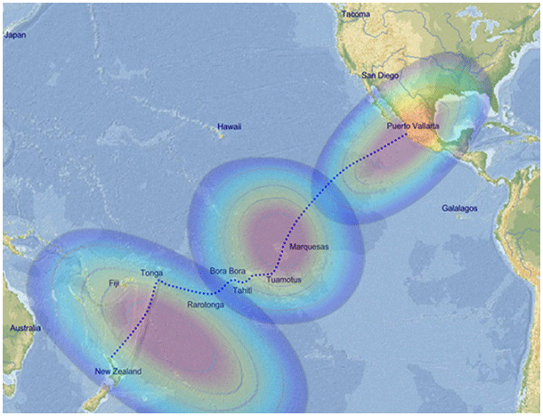
A route traversing three satellite footprints
This application could be bundled with your maritime TVRO sales to make your product stand out and to increase sales. Main product features could also include the following:
![]() Route mapping
Route mapping
![]() Current location indicated on the satellite footprint maps
Current location indicated on the satellite footprint maps
![]() Automatic system updates via the internet at regular intervals
Automatic system updates via the internet at regular intervals
![]() Database with contact details for all TV channel package providers
Database with contact details for all TV channel package providers
![]() Database with dealers and service partners (nearest one can be selected using GPS position)
Database with dealers and service partners (nearest one can be selected using GPS position)
![]() TV channel logotypes
TV channel logotypes
If you feel that this could add to your product set we would be delighted to hear from you. Please contact us at info@satstar.net for more information.


and TV guide data from the internet
SatStar can provide detailed technical information about commercial geostationary satellites. It can be used by professionals, e.g. for budget link calculations, and can easily be integrated into custom applications.
All data can be stored in a database, including downlink and uplink coverage maps, frequency plans, transmissions, TV/radio channels etc. For more information, please refer to the Satellite Data page.
