Are you looking for detailed technical information about commercial geostationary satellites: downlink (EIRP) and uplink (G/T) coverage/footprint maps, frequency plans, transmissions, TV/radio channels etc?
Some information is very hard to find and not available from one source. If you find what you are looking for, you have to spend a lot of time processing the information to be able to use it and, still, there are probably a lot of data which is not in the correct format. SatStar has the solution to the problem.
SatStar maintains a database of all this information. It can be used by professionals, e.g. for budget link calculations, and can easily be integrated into custom applications. All data can be delivered in a format of your choice.
If you are looking for functionality, rather than data only, we can help you access information by creating a web interface on the SatStar website for database queries that suits your specific requirements. We can also provide you with an API, e.g. a SOAP interface, to perform remote custom queries from your own website or from your own application, e.g., "List receivable satellite FTA sport channels in German at a particular location".
To illustrate how data can be used, please have a look at our free interactive BeamFinder tool. It enables the user to specify a location (longitude/latitude, nearest city/port, or by clicking on a map) and size of antenna and receive a complete list of available satellite beams which can be received at that specific location with that particular antenna size.
Below you will find examples of satellite data that SatStar can provide. For more information, or if you would like to discuss any specific requirements, please do not hesitate to contact us at info@satstar.net.
Satellites
![]() General information (launch date and site, owner/operator, contractor etc.)
General information (launch date and site, owner/operator, contractor etc.)
![]() Information about related ITU/FCC filings
Information about related ITU/FCC filings
![]() Orbit information (Two Line Element)
Orbit information (Two Line Element)
![]() Beam information
Beam information
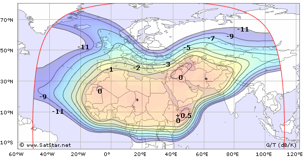
Footprints/Coverage Maps
![]() 4,525 downlink (EIRP) maps
4,525 downlink (EIRP) maps
![]() 3,959 uplink (G/T) maps
3,959 uplink (G/T) maps
![]() All maps are available as images, as vector data (polygons or Bezier curves) or as raster data
All maps are available as images, as vector data (polygons or Bezier curves) or as raster data
Arabsat 5A, Uplink C-band Beam
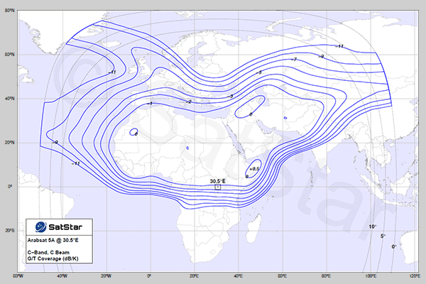
Sample Preview (Click on the image to download a PDF hi-res vector graphics sample)
Frequency Plans
![]() Transmit/receive channels
Transmit/receive channels
![]() Transponders
Transponders
![]() Beacons
Beacons
Transmissions
![]() Transponder
Transponder
![]() Frequency
Frequency
![]() Symbol rate
Symbol rate
![]() FEC
FEC
TV and Radio Channels
![]() Channel name
Channel name
![]() Content
Content
![]() Language
Language
![]() Encryption
Encryption
![]() Compression
Compression
![]() Resolution
Resolution


and TV guide data from the internet
SatStar can provide detailed technical information about commercial geostationary satellites. It can be used by professionals, e.g. for budget link calculations, and can easily be integrated into custom applications.
All data can be stored in a database, including downlink and uplink coverage maps, frequency plans, transmissions, TV/radio channels etc. For more information, please refer to the Satellite Data page.
